Hurricane Idalia neared the Florida coast at the same time Hurricane Franklin, with a clearer eye wall, churned in the Atlantic on Aug. 29, 2023.
NASA via Wikimedia
Vertical wind shear can keep tropical storms in check, particularly during El Niño years. When El Niño is gone, it’s a different story.
Bureau of Meteorology/AAP
Cyclones and hurricanes are getting more intense. But introducing new categories of storm may not be the answer.
Flood water filled streets in downtown Montpelier, Vt., on July 11, 2023.
Kylie Cooper/Getty Images
An atmospheric scientist explains how rising temperatures are helping to fuel extreme storms, floods, droughts and devastating wildfires.
Extreme downpours filled downtown Montpelier, Vt., with water in July 2023.
John Tully for The Washington Post via Getty Images
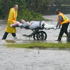
The US saw a record number of billion-dollar disasters in 2023, even when accounting for inflation. The number of long-running heat waves like the Southwest experienced is also rising.
Hurricane Otis gave Acapulco almost no time to prepare.
Xinhua / Alamy
A deadly hurricane developed in just 12 hours.
A car washed out to sea by floods in Greece.
Thodoris Nikolaou/AP
We all know climate change makes extreme weather more likely. But it’s also loading the dice for quick-forming drought, sudden and intense rainfall and fast-forming tropical storms.
A satellite captured Tropical Storm Idalia’s convection as it gained strength off Cuba on Aug. 28, 2023.
NOAA GOES
A hurricane scientist explains the conflict between 2023’s abnormally high ocean heat and the storm-disrupting wind shear accompanying El Niño.
A natural weather event known as El Niño is underway in the Pacific Ocean.
jon sullivan/Shutterstock
An El Niño weather-warming phase is underway in the Pacific – but what does this mean for the weather in Europe?
Satellite data illustrates the heat signature of Hurricane Maria above warm surface water in 2017.
NASA
Currents can carry that deep ocean heat hundreds of miles to surface again at distant shores.
Twenty years of storm tracks in the Atlantic and eastern Pacific basins.
NASA
El Niño years put Hawaii and the Mexican Riviera on alert for destructive tropical storms and hurricanes.
The fishing village of Mahebourg, Mauritius, is among the places in the path of cyclone Freddy.
Laura Morosoli/AFP via Getty Images
Tropical cyclones are becoming more frequent in the Indian Ocean. Here’s why and what that means.
The Bahama warbler (Setophaga flavescens) is endemic to the Bahamas.
Blickwinkel/Alamy Stock Photo
The Bahama warbler favours large pine trees and palms, fieldwork shows.
Natural hazards inflict damage on ports worldwide.
Harvepino/Shutterstock
Natural disasters cause billions in damage to ports around the world each year.
Hurricane Nicole was a Category 1 storm, but it caused extensive damage to Florida in 2022.
Lauren Dauphin/NASA Earth Observatory
Research shows storms that might have caused minimal damage a few decades ago are becoming stronger and more destructive as the planet warms.
Nursing homes patients had to be evacuated after Hurricane Ian cut access to safe water supplies.
AP Photo/John Raoux
Coastal hospitals are still at high risk, nearly two decades after Hurricane Katrina’s flood disaster at Memorial Medical Center shocked the world.
Hurricane Ian gained strength as it headed over warm waters off Cuba on Sept. 26, 2022.
NOAA
Much of the state is at risk of heavy rainfall, and the coast could see devastating storm surge, particularly around Tampa Bay.
A Canadian flag waves in the high winds in Dartmouth, N.S. on Sept. 24, 2022.
THE CANADIAN PRESS/Andrew Vaughan
Hurricanes don’t usually maintain high wind speeds as they make their way toward Atlantic Canada. But ocean warming may be linked to the increasing intensity of storms like Fiona.
Muhammad Qadri Anwar/Shutterstock
High humidity, terrain and wind make rain forecasting particularly tricky in the tropics.
The Wall of Wind can create Category 5 hurricane winds for testing life-size structures.
Margi Rentis/Florida International University
The test facility in Miami helps building designers prevent future storm damage. With the warming climate intensifying hurricanes, engineers are planning a new one with 200 mph winds and storm surge.
Southern Africa’s summer rainfall regions currently experiencing the wet-season will likely continue having wetter than normal conditions.
SimpleImages/Getty Images
Southern Africa’s current above-average rainfall is a climate variability signal - a short-term fluctuation in average wet-season conditions.